Friday, July 22, 2011

Extreme Weather Sweeping the US

It's everywhere. Roads buckling from the heat in Minnesota, cattle dying by the thousands in South Dakota, and crowds of sweaty commuters crowded around the slightest hint of an air conditioned breeze on the DC metro. This heat wave, along with droughts in Texas, wildfires in Arizona, floods in the Midwest, and tornadoes in the South, have got everybody thinking about extreme weather events and their possible connection to climate change.

To confirm the facts and dispel the myths, the head of the Climate and Energy Program at the World Resources Institute will be holding a live Q & A on the Washington Post's website today. This will be followed by an editorial piece, "5 Myths about Extreme Weather" in the paper this weekend. Make sure to check it out.

Thursday, June 30, 2011

Debates over Hydraulic Fracturing

natural gas drilling
Photo courtesy of Helen Slottje for www.shaleshock.org

The use of hydraulic fracturing to exploit unconventional sources of natural gas is perhaps the most  divisive new development in domestic energy technology this decade. Hydrofracking, or "fracking" as it is commonly called, is the process by which pressurized fluid intrudes into a rock formation, resulting in the fracture of bedrock. Increasingly, this technique is used in natural gas extraction where pressurized water, chemicals, and propping agents are injected into a wellbore in order to induce and maintain fractures at-depth in gas-bearing formations. This technology has recently allowed the profitable exploitation of “unconventional” natural gas deposits, which includes shales, coalbeds, and tight sands (EPA, 2011).  

The potential energy resources of unconventional gas deposits are predicted to be significant (comprising up to 60% of onshore gas resources), and in the United States may end up providing an alternative to imported fossil fuels and “dirtier” energy sources such as coal (DOE, 2009). Recent estimates by the Energy Information Administration predict over 2,552 trillion cubic feet of recoverable natural gas in the U.S., enough to supply the nation for 110 years at current rates of production (EIA, 2010). The largest reservoirs of the newly available gas are stored in shale basins spread across the eastern, southern, and central U.S. This includes the Barnett formation in Texas, the Fayetteville formation in Arkansas and Oklahoma, and the Marcellus formation, which extends from Tennessee up through New York. Natural gas exploration and production in these regions has increased exponentially over the last few years. In the U.S. in 2008, the number of natural gas and condensate wells increased 5.7%, reaching an historic peak of 478,562 wells (Kargbo et al., 2010).

Those wells which employ hydraulic fracturing, however, are increasingly coming under scrutiny as new concerns have emerged about the environmental and health impacts of this new technique. A single HF operation can require millions of gallons of hydraulic fracturing fluid- a mixture of water, a proppant such as sand or ceramic beads, and up to 750 chemicals and other components. A recent Congressional investigation determined that between 2005 and 2009, HF operations used at least 29 chemicals that are either human carcinogens (such as benzene and lead), regulated under the Safe Drinking Water Act, or regulated under the Clean Air Act (U.S. House of Representatives, 2011). There is widespread public concern about the threat to drinking water safety, as well as concern that the oil and gas service companies and regulatory agencies are not aware of the full range of dangers or even the ingredients in HF fluid (Urbina, 2011). To assess the exact risk to drinking water resources, the EPA has recently initiated a study of the full lifecycle of HF production (EPA, 2011).

Widespread public resistance to hydraulic fracturing has taken on a number of forms, from popular documentaries ("Gasland") to regular and solicitous articles in the New York Times. Bus stops ads in Manhattan show a vacationer tubing on a lake wearing a silver hazmat suit. Concerned community groups have rallied in rural areas where drilling has been extensive. Counter-point arguments come forth from industry executives, but not many other sources.

So, is the drilling actually harmful? I attended a seminar on this subject at this year's annual meeting of the American Academy for the Advancement of Science. Geologists, engineers, and sociologists contributed to what was probably the most heated debate at an otherwise sedate conference. While some believed the drilling to be harmful and others insisted it was benign, the most salient message was that more research needed to be done on the subject. The EPA is pushing forward with a large study now, but this is a multi-dimensional issue, with environmental, hydrologic, health, economic, and sociological implications. It may take many studies more to approach an accurate assessment of the risks.

Sources:

Associated Press (April 2011) Pennsylvania: Drilling Technique Suspended After Spill. National Press Briefing, Washington D.C.

EIA, Annual Energy Outlook 2011 Early Release (December 2010); EIA, What is shale
gas and why is it important? (online at www.eia.doe.gov/energy_in_brief/about_shale_gas.cfm)
 
Kargbo, David, Ron Wilhelm, and David Campell (2010) Natural Gas Plays in the Marcellus Shale: Challenges and Potential Opportunities. Environmental Science & Technology. 44:5679-5684.

Urbina, Ian (February 2011) Regulation Lax as Gas Wells’ Tainted Water Hits Rivers. The New York Times, February 27, 2011.

U.S. Environmental Protection Agency, Office of Research and Development (February 2011) Draft Plan to Study the Potential Impacts of Hydraulic Fracturing on Drinking Water Resources. Washington D.C. Report, 140 pp.

U.S. House of Representatives, Committee on Energy and Commerce, Minority Staff (April 2011) Chemicals Used in Hydraulic Fracturing. Washington D.C. Report, 32 pp.

U.S. Department of Energy (2009) Modern Shale Gas Development in the United States: A Primer; DE-FG26-04NT15455; U.S. DOE: Washington, D.C.


Sunday, June 12, 2011

More geology photos


I've been posting a bunch of new geology photos to my Flickr account. Check it out!

Thursday, June 9, 2011

Geology of Great Falls, VA


With hundreds of millennia of continental collision, mountain-building, and eroding coasts, the Eastern seaboard is full of rich geological stories. For residents of the Mid-Atlantic, many of them are visible at the Great Falls National Park that straddles the Potomac upstream of DC. Here are a few highlights of a recent trip there with the Smithsonian Paleobiology Training Program. 


Metagraywacke (shown above) of the Mather Gorge formation underlies much of the landscape here. You can read an old sedimentary pattern in the cross-bedding that bends across the stone. This metagraywacke formed deep underwater at the bottom of an abyssal plain, where debris from the continental slope roiled down in huge underwater landslides called turbidity currents. As the sediment settled out after these distinctive events, it formed the bedding you see here, which lithified over 570 millions years ago.

When Africa and Europe collided with North America, this bedrock underwent massive metamorphism, which is apparent in the tortuous patterns in the rock.


Despite the sturdy nature of the metagraywacke, it gave way before an advancing Potomac River, which cut a deep gorge here along an ancient fault line.
 This gorge, in turn, is pocketed with ecological nooks and crannies, providing habitat for a number of different species. This includes the Green Frog (Rana clamitans), enjoying the microhabitat of a water-filled pothole.

                                
But dangers lurk for unsuspecting amphibians. Only a few hundred feet away, this 5-ft long Black Racer (Coluber constrictor) was taking advantage of a rocky crevice to conceal himself.


 Great Falls, thanks to its status as a National Park, is full of natural gems like this. It wasn't long ago, however, when this land was prime prospecting ground for gold, which fills the quartz veins cross-cutting the bedrock. From the Civil War until the 1940's, gold was actually mined here, and it doesn't take long to see evidence of it.
The stream on the left is contaminated by acid mine drainage, causing high levels of iron and blooms of iron-digesting bacteria. Mitigating pollution like this can be very difficult, since it involves tracing groundwater on its convoluted path back to the contaminant origin. Knowing the geology of the area is a good place to start! Explore Callan Bentley's excellent guide for more information.
 

Monday, May 9, 2011

Geology of Theodore Roosevelt Island


A few weeks ago, I had the good fortune to accompany the Smithsonian Paleobiology department on a field trip to Theodore Roosevelt Island, a tiny bit of land in the middle of the Potomac river, between Washington DC and Virginia. The island represents a neat little microcosm of history in our nation's capital, from the time when it was housed a populous Nacotchtank fishing village (first recorded by Capt. John Smith as he sailed up the Potomac), to the days when it was cleared for the manor of John Mason (son of George Mason, the early American statesman), to the current day where it boasts a granite monument for Teddy Roosevelt. Today, most of the island's 80-odd acres are covered with forest, wetlands, and rocky outcrops.

For students of geology, the island is a great place to observe many distinctive regional features and landscape morphologies. Perhaps the most significant is the "Fall line" that bisects the island- an unconformity where hard bedrock (schist and gneiss of the Piedmont Province) stands in relief against an eroded plain of soft sediments (called the Coastal Plains Province.) This is a local expression of a much larger continental feature-the 900-mile Atlantic Seaboard Fall Line that runs from New Jersey to Georgia. On the island it is not much more than a low slope, but it serves as a great illustration of the geology, unobstructed by buildings or roads. .
(Image adapted from Google Earth Image, after Crowley, William 1976.)


The image above shows how the bedrock of the Piedmont slopes down under the Tertiary and Cretaceous sediments that constitute the Mid-Atlantic coastal plain. DC, like Theodore Roosevelt Island, is neatly divided by this line, with northwestern neighborhoods like Georgetown, Adams Morgan, and Cathedral Heights perched high on the Piedmont and the rest (including the National Mall) lying low on the Coastal Plains. 
Through out much of DC, the visible Piedmont bedrock belongs to the Sykesville Formation. On the island it appears as schist (a rock composed of metamorphosed ancient mud layers) rich in garnet and biotite mica. The garnets represent inclusions that were especially rich in iron, magnesium and aluminum.


Scattered among the native bedrock there are some river-rounded stones brought in for filling gravel paths. On one of these, we were lucky enough to find the fossil trace of a prehistoric burrowing worm called Skolithos.
 

Another interesting feature is the presence of ubiquitous shoreline structures like natural levees and backswamps (see below, with the office buildings of Rosslyn in the background.) As sediment washes up on shore it piles up and is anchored by tree roots, building a low, long mound along the shore. Underground seepage, however, allows river water to form marshy "backswamps" where water-logged conditions prevent the growth of trees.


It is astounding how geologically rich such a small piece of land can be. And while Theodore Roosevelt Island is certainly special, it is not necessarily unique- there are many pockets of geological knowledge to be discovered all around Washington DC.

Thanks to Dr. Ray Rye, leader of the expedition. 

Further Reading: 
Means, John (2010). Roadside Geology of Maryland, Delaware, and Washington DC. Missoula: Mountain Press Publishing Company.

Monday, March 14, 2011

Tsunami and earthquake devastate Japan

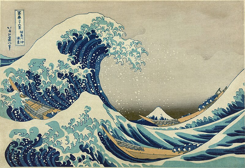
File:Great Wave off Kanagawa2.jpg
"The Great Wave Off Kanagawa" by Katsushika Hokusai, 1826-1833
The news is now filled with images and stories of the continuing destruction on Honshu, the most populous island in Japan. After a magnitude 8.9 earthquake that shifted the sea floor in the Western Pacific and displaced a huge quantity of water, a massive tsunami rolled over Japan's coast.The damage is immeasurable: billions of dollars, threats of a nuclear meltdown, and over1,600 lives confirmed lost.

More posts on this event will follow, but I want to take this moment to wish good luck to all those who are still searching for friends and family. We should also all hope that the major damage is done and that no more pain will be visited on the victims of the tsunami.

Stay safe.

Thursday, March 10, 2011

The Incredible Crater Collapse


(The collapse of the Puʻu ʻŌʻō Crater in Hawaii. Courtesy of the USGS)

Last night, I attended the 1449th Meeting of the Geological Society of Washington , which meets at the Cosmos Club- the intellectual society founded by John Wesley Powell, one-armed Civil War vet and geologist extraordinaire. Preceding the evening's lectures, Dr. Roz Helz of the USGS (ret.) and the (The Hawaiian Volcano Observatory) brought forth an "informal communication" before the group. Her presentation highlighted the video above, which was recorded on March 5th by the HVO's extensive video monitoring system on several major volcanoes and vents, from Mauna Loa (the most voluminos mountain in the world) to Kilauea (one of the most active volcanoes in the world.) This particular video shows the latter, specifically an outlet called the Puʻu ʻŌʻō Crater. The time-lapse video shows from 4 AM to 11 PM, where runny basaltic lava poured out and hardened on the crater floor, only to collapse 377 feet into a hellish looking pit. I would have loved to hear a bit more explanation about how this happened, but my guess is that the magma plume that was rising underneath the crater subsided quickly, either because of changing pressure and temperature in the Earth's crust, or because the magma was diverted elsewhere. The crust of dried lava on top appears to keep accumulating puddles of lava from smaller side vents until the weight is too great. It is impressive how much steam and gas escapes from the crater once the top is broken.

It is a great illustration of the liquidy, syrup-like lava of basaltic volcanoes with their low viscosity. (Hawaii's volcanoes are fed by basaltic magma, which is low in thickening silica, unlike a stratovolcano like Mt. St. Helens.) According to Hawaiian tradition, the name for the Puʻu ʻŌʻō crater derives from the word for "digging stick." It was apparently, Pele, the goddess of volcanoes, who created these structures using the tip of her giant staff. I think all of us in tectonically stable areas can be glad that she didn't walk over our homes.

Monday, March 7, 2011

The Anthropocene

Scale not to scale.
Geochronology is usually considered a rather obscure topic for the public discourse, but maybe that is about to change. Monday’s New York Times ran an editorial about efforts to demarcate a new geological epoch, a period of time usually lasting tens of millions of years and defined by a distinct set of global conditions. Previously, geological time periods have been determined primarily by the rock record (for example, the iridium-rich “K-T boundary,” a chalk layer that marks the end of the Cretaceous period and indicates the ash of the dinosaur-killing asteroid.) This proposed epoch, however, would be defined by a very recent, ongoing process: the busy activities of our own species.

Recognizing the “Anthropocene,” as it has been called, would mark not only a major installment in the official record of the Earth’s history (as established by the International Commission on Stratigraphy), but would also indicate a shift in the way we think about our relationship with the inorganic edifice of our planet. The new epoch, first proposed by Nobel-prize winning chemist Paul Crutzen, would be defined by the particular activities of our species that cause major global change and leave a measurable lithostratigraphic signal in the rocks of the distant future. This would include large-scale agriculture, the creation of major cities, the curtailing of global biodiversity, the alteration of sediment transportation by dams and mills, and of course the burning of fossil fuels and subsequent alteration of our atmospheric and oceanic chemistry.  According to Zalasiewicz et al. writing for the Royal Society, who just published a theme issue on the Anthropocene, “current evidence seems to show global change consistent with the suggestion that an epoch-scale boundary has been crossed within the last two centuries” (Introduction 840).

There is strong support for this idea, even a budding consensus. The Geological Society of London decided in 2008 that the proposal was worthy of further investigation, and the Geological Society of America has hosted conferences centered around the question of whether the Anthropocene should be added to the Geologic Time Scale.  Some proponents note that the legitimacy of our current epoch, the Holocene (11,700 ya – present,)  has been long debated, as evidence indicates that it may not be distinct, but simply an inter-glacial period in the middle of the Quaternary Ice Age. In a sense, the Holocene itself may exist to provide geologists with a reference point for the modern age, something by which to classify the soils and rocks that are forming today (Zalasiewicz et al. 837).

This debate is fascinating because it exposes a qualitative dynamic to our comprehension of Earth’s history.  How do you decide what constitutes a distinct geologic age? Events like mass extinctions or planetary-scale glaciations seem like obvious benchmarks, but what about the finer differentiations? Rock formations differ from location to location- a layer of shale that European scientists designated as the dividing line between two eras may not be present in other continents. The International Commission on Stratigraphy reconciles these differences by comparing lithographic formations with the best available data on global climate conditions, but it is not a simple task. At some point, scientists have to make judgment calls on what events constitute chapter headings in the history of our world.

Does it begin with agriculture?
Or maybe with industrial activity?
The Anthropocene, for example, may arguably have begun at the onset of the Industrial Revolution, when human communities first started to harness the power of truly complex machines, generate power from the combustion of fossil fuels, and amplify their systems of production through increased efficiency. These ongoing processes are leaving tell-tale signals, from increased CO2 levels in the gas trapped in glaciers to measurably warmer global temperatures to landscape change caused by the growth of cities and suburbs. On the other hand, some scientists have argued that the Anthropocene may have started as much as 6000 years ago, when agriculture was first developed in the Fertile Crescent and began to change the balance of CO2 in the atmosphere.   One might also argue you could approximately swap of the Anthropocene for the Holocene, because of the mass extinctions of North American megafauna (mammoths, giant sloths, saber-tooth tigers, and the like) that coincided with the arrival of humans on the continent.

Large cities leave a measurable signal.


As far as the general public is concerned, the Anthropocene debate holds interest because it is happening adjacent to the highly politicized discussion about how we should respond to anthropogenic climate change. Some will inevitably respond with a roll of the eyes- “Here the researchers go again, politicizing the science to put pressure on the government.” Others will champion the would-be-epoch simply to implicate humanity for its carbon sins. Neither approach is the right way to see the problem- if we add an epoch, it should be to enhance our understanding of the planet and give us a vocabulary to explain it. The geologic time scale, like the system of taxonomy for biologists, is a human tool laid over a natural reality so complex that we can hardly comprehend it.  If you lay a grid over a Monet in hopes of understanding his use of color and light, you are bound to miss some of the subtlety and detail. Still, you have to be impressed with the job researchers have done this far- after all, they are working with a singular masterpiece.

Thursday, February 24, 2011

Review of "Strong Motion"


Review of Strong Motion
Jonathan Franzen
Picador Press, 1992

I picked up this book after having read and enjoyed two of Franzen’s bestsellers: 2001’s The Corrections and 2010’s Freedom. These sprawling, ambitious critiques of post-modern American life have made Franzen a favorite of critics and fiction aficionados.  Generally, his novels drift from character to character, exploring their convoluted personal histories as they converge around a central conflict. More often than not, this conflict surfaces as a multi-generational corporate conspiracy. I am a big fan of his precise and descriptive prose, but it is too easy to despise his characters for their willful fallibility, self-interest, and inability to be decent to one another.
Before he was famous enough to snub Oprah’s book club (which he did, notoriously  in 2001), Franzen wrote a novel about earthquakes. Well, he wrote his usual novel, in which emotionally damaged individuals rattle in their dysfunctional families and unhealthy romances. But one of his main characters is a Harvard seismologist, and earthquakes persist throughout the book as metaphors and plot devices. 

Louis Holland is a cynical college graduate who, feeling detached from society, isolates himself in a mundane job and retreats to his working-class suburb of Boston. When an unexpected Massachusetts earthquake kills an eccentric grandmother, issues over her inheritance inject new conflict into his already neurotic family. Louis meets Renée Seitchek, a young Ph.D candidate at Harvard who is investigating the origin of the tremors. As their romance develops, so does a narrative about the corporate malfeasance that underlies the seismicity.
Sweeting-Aldren, a DuPont-like chemical company, sits squarely on top of the earthquake epicenters. Partly out of academic interest, partly out of meanness towards family members who own stock in the company, and begrudgingly out of a sense of justice, Louis and Renée begin an investigation of the company’s ability to rupture New England’s dormant faults. They discover that in the 60’s Sweeting-Aldren may have drilled a 25,000 foot-deep exploratory hole in a misguided search for deep petroleum reserves. There is also a mystery as to the location of thousands of gallons of the company’s toxic waste. If Sweeting-Aldren has been pumping their waste deep under-ground, they conjecture, then they could be inducing seismicity through high fluid pressures and lubrication of ancient fault structures.

Readers who approach this book out of an interest in geophysics will discover that 90% of the novel is dedicated to developing the characters and exploring their personal vulnerabilities.  However, if you like some existential musing with your seismology, it is well worth the read. Franzen is not a geophysicist, but his meticulous research makes the book convincing and elegant.  The subplot concerning induced seismicity seems feasible (at least to me), and the novel cites several real-world examples.  There was the famous 1960’s incident when the US Army pumped waste into an old borehole at the Rocky Mountain Arsenal, outside Denver. Earthquakes ensued. When the Army stopped pumping, the earthquakes stopped.(see Hsieh and Bredehoeft’s 1981 paper in the Journal of Geophysical Research for more.) 

Part of what makes Franzen’s book worth reading now, twenty years after its publication, is the new relevance induced seismicity has for the geological community. Man-made reservoirs are known to be a source of earthquakes as the weight of dammed river forces pressurized water into faults. Reservoir-induced earthquakes may have caused hundreds in India and are a cause of concern over China’s Three Gorges Dam. Very recently, a geologist named Markus Haring was sued for inducing over 30 earthquakes while developing an enhanced geothermal project in Switzerland. Enhanced geothermal is basically similar to what happens in Strong Motion, without the toxicity- bedrock is fractured and pressurized water is injected at subsurface depths up to 5 km. The circulated water is turned into steam by heat and pressure, but unfortunately, this also tends to induce seismic activity. Hydraulic fracturing is also an important element of shale-gas extraction, and in the next few years we may see swarms of induced earthquakes showing up in Pennsylvania, New York, and Texas (some large earthquakes associated with shale gas drilling have already shaken Arkansas, in a story eerily similar to Franzen's.) 
I don’t know of any cases where real companies have induced earthquakes for such despicable reasons as Franzen’s fictional conglomerate, but the story is compelling. This is in large part due to the author’s ability to unpack the perceptions of geoscientists when natural disasters loom.

“By and large, the media and the public assumed that the research groups would issue urgent warnings if a cruncher appeared imminent; that this was what they’d come to Boston for. The groups themselves had no such plans. They were scientists and had come to gather information and advance their understanding of the earth. They knew, in any case, that the governor would never take the economically disruptive step of issuing an all-out warning unless most of the prediction methods agreed that a major shock was due. In the past, the methods had specifically not agreed about the timing, severity, and location of major earthquakes. This was why the methods were still being tested. When the groups said so, however, the public took it as modesty and continued to assume that somehow, should a disaster loom, a warning would be issued” (p. 248).

Few researchers, I think, would actually be so unconcerned about potential human suffering. However, this paragraph seems a neat little representation of the miscommunication that so often characterizes the exchange between experts and the public. Franzen also offers a cutting critique of the way that we tend to fetishize natural disasters:

 “And now the disaster which had been promising to make you feel that you lived in a special time, a real time, a time of the kind you read about in history books, a time of suffering and death and heroism … now a disaster of these historic proportions had come, and now you knew it wasn’t what you wanted either… because now you could see that the earthquake was neither history nor entertainment. It was simply an unusually awful mess” (p. 471).

This is a poignant reminder of the pain endured in very real earthquakes- such as the recent  Christchurch quake in New Zealand. I think there are few victims who would say they were ennobled by the experience. Acts of heroism and selflessness certainly took place and were vital in saving lives, but the look on everyone’s face says that they wish the quake had never happened.  
Liquefaction of the ground in New Brighton. Credit to Martin Luff.


Topical and carefully-written- I would recommend this book.

Tuesday, February 22, 2011

Earthquake in Christchurch

 News is still just reaching the Western hemisphere concerning the devastating 6.3-magnitude earthquake that struck the city of Christchurch, New Zealand early this morning. Though this event follows on the heels of September's larger, 7.1-magnitude event, this earthquake has been far more damaging. The death toll is already at 65 and is likely to rise as they uncover more of the deceased. Unreal images of destruction and suffering have already saturated the news.


You can donate to the victims through the Red Cross's New Zealand chapter.

Wednesday, February 9, 2011

Dear Old Hibernia

 A short while ago, I made the  trans-Atlantic flight to visit my girlfriend who was finishing her degree in the UK. As a break from the vivas and theses, we made a quick trip to the little exclave of Northern Ireland. The Emerald Isle is no less verdant and attractive on the Commonwealth side of the line, and the landscape abounds with geological curios. 


We followed the northern coast, where primeval-looking white washed cottages perch on the shoulders of big grassy hillsides. A short trip down this coastal highway will lead you to "The Giant's Causeway", a segment of coast honeycombed with columnar basalt that has become the most visited tourist site in Northern Ireland.

The rich-colored rocks form giant pillars in some places and have been worn down to a neat polygonal cobblestone pattern in others. The banner photo for this blog shows an example of the latter. This "columnar basalt" is the result of an ancient lava flow, where low-viscosity molten rock poured out into broad plains and plateaus. In the case of this site, the flood basalts stretched out for over 700,000 square miles during the Paleogene period  (50-60 mya.) As the lava quickly cooled, it contracted vertically, then horizontally, creating the regular network of fractures.
           (1768 engraving by Susanna Drury)

The Irish of years past must have agreed that the eroded pillars look like an oversized cobble-stone path. The etiological myth of the "Giant's Causeway" is built around the cultural hero Finn McCool (Fionn mac Cumhaill in the original Gaelic.) In legend, this giant hunter-warrior built the Giant's Causeway as a bridge to Scotland in order to keep his feet dry. In another version, he built the structure while preparing to attack a Scottish adversary, but then tore it up when he saw the size of his opponent. The geology behind this tall tale is not entirely baseless- the same basaltic plateau that we see in Ireland once stretched all the way across the Irish Sea and similar columnar basalts can be found at Fingal's Cave in Scotland.

The real "bridge to nowhere"


If Finn McCool's feet supposedly pounded natural wonders into the Emerald Isle, than his name lent symbolic power to its politics. The Fenian Brotherhood, formed by in 1858 by Irish emigrants to the US gave expression to anger and frustration at centuries of British colonial rule in their home country. Incensed by unfair land tenure and economic oppression, this  movement organized political support for Irish independence and even went so far as to invade forts in British-administered Canada. The idea of a few hundred 19th century Irish nationalists invading Canada seems quaint nowadays, but a quick trip to Belfast shows that the tensions are not that far behind us.

The industrial cities of Belfast and Derry are both littered with colorful murals, some pleading for peace- others with more sectarian aims.  

On the left is a mural in the bricked-in Catholic ghetto of Free Derry. The dove grows out of an oak leaf, a traditional symbol of the town. The frightening mural on the right stands on a Unionist stretch of the Shankill Road in Belfast. The caption reads "A Protestant wife defends the farm against intruders."The very day after our visit, a traditional celebration in a Unionist neighborhood went horribly wrong, with several police offers being injured by gunshots and rocks.

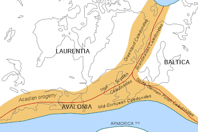
Imagine the earth six hundred million years ago. The Irish landmass was actually two separate islands, divided by the vast Iapetus Ocean. Northwestern Ireland balanced on a microplate grouped with Laurentia while southern Ireland (along with the mass of England) belonged to the smaller Avalonia continent.
Map courtesy of Wikiuser Woudloper. The red lines represent sutures and orogenies.

It took 50 million years, but tectonic engines brought these disparate parts crashing together in a fateful union. Ireland has been one island since. How much longer will it take for the residents to realize that today's partition is only in their minds?

Courtesy of NASA.


Nature Blog Network